


MapArt • SKU: 1017723
MapArt Ontario Back Road Atlas
MapArt Ontario Back Road Atlas
Members save More!
CAA Members receive additional savings on all items when shopping online and at CAA Stores.
Plus Members also receive an extra 5% off the Member pricing and Premier Members receive an extra 10% off the Member pricing.
Learn MoreOut of stock
Couldn't load pickup availability


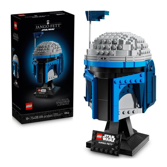
Members Save on LEGO®
Explore our collection of LEGO® products from travel-inspired sets, vehicles, accessories and more. Plus, enjoy Member-exclusive pricing.
Members Save on LEGO®
Explore our collection of LEGO® products from travel-inspired sets, vehicles, accessories and more. Plus, enjoy Member-exclusive pricing.
Shop Our LEGO® Collection


Members save More!
CAA Members receive additional savings on all items when shopping online and at CAA Stores.
Plus Members also receive an extra 5% off the Member pricing and Premier Members receive an extra 10% off the Member pricing.
Learn More

Members save More!
CAA Members receive additional savings on all items when shopping online and at CAA Stores.
Plus Members also receive an extra 5% off the Member pricing and Premier Members receive an extra 10% off the Member pricing.
Learn More

Members save More!
CAA Members receive additional savings on all items when shopping online and at CAA Stores.
Plus Members also receive an extra 5% off the Member pricing and Premier Members receive an extra 10% off the Member pricing.
Learn More

Members save More!
CAA Members receive additional savings on all items when shopping online and at CAA Stores.
Plus Members also receive an extra 5% off the Member pricing and Premier Members receive an extra 10% off the Member pricing.
Learn More

Members save More!
CAA Members receive additional savings on all items when shopping online and at CAA Stores.
Plus Members also receive an extra 5% off the Member pricing and Premier Members receive an extra 10% off the Member pricing.
Learn More

Members save More!
CAA Members receive additional savings on all items when shopping online and at CAA Stores.
Plus Members also receive an extra 5% off the Member pricing and Premier Members receive an extra 10% off the Member pricing.
Learn More

Members save More!
CAA Members receive additional savings on all items when shopping online and at CAA Stores.
Plus Members also receive an extra 5% off the Member pricing and Premier Members receive an extra 10% off the Member pricing.
Learn More

Members save More!
CAA Members receive additional savings on all items when shopping online and at CAA Stores.
Plus Members also receive an extra 5% off the Member pricing and Premier Members receive an extra 10% off the Member pricing.
Learn More

Members save More!
CAA Members receive additional savings on all items when shopping online and at CAA Stores.
Plus Members also receive an extra 5% off the Member pricing and Premier Members receive an extra 10% off the Member pricing.
Learn More

Members save More!
CAA Members receive additional savings on all items when shopping online and at CAA Stores.
Plus Members also receive an extra 5% off the Member pricing and Premier Members receive an extra 10% off the Member pricing.
Learn More

Members save More!
CAA Members receive additional savings on all items when shopping online and at CAA Stores.
Plus Members also receive an extra 5% off the Member pricing and Premier Members receive an extra 10% off the Member pricing.
Learn More

Members save More!
CAA Members receive additional savings on all items when shopping online and at CAA Stores.
Plus Members also receive an extra 5% off the Member pricing and Premier Members receive an extra 10% off the Member pricing.
Learn More

Members save More!
CAA Members receive additional savings on all items when shopping online and at CAA Stores.
Plus Members also receive an extra 5% off the Member pricing and Premier Members receive an extra 10% off the Member pricing.
Learn More

Members save More!
CAA Members receive additional savings on all items when shopping online and at CAA Stores.
Plus Members also receive an extra 5% off the Member pricing and Premier Members receive an extra 10% off the Member pricing.
Learn More

Members save More!
CAA Members receive additional savings on all items when shopping online and at CAA Stores.
Plus Members also receive an extra 5% off the Member pricing and Premier Members receive an extra 10% off the Member pricing.
Learn More

Members save More!
CAA Members receive additional savings on all items when shopping online and at CAA Stores.
Plus Members also receive an extra 5% off the Member pricing and Premier Members receive an extra 10% off the Member pricing.
Learn More

Members save More!
CAA Members receive additional savings on all items when shopping online and at CAA Stores.
Plus Members also receive an extra 5% off the Member pricing and Premier Members receive an extra 10% off the Member pricing.
Learn More

Members save More!
CAA Members receive additional savings on all items when shopping online and at CAA Stores.
Plus Members also receive an extra 5% off the Member pricing and Premier Members receive an extra 10% off the Member pricing.
Learn More

Members save More!
CAA Members receive additional savings on all items when shopping online and at CAA Stores.
Plus Members also receive an extra 5% off the Member pricing and Premier Members receive an extra 10% off the Member pricing.
Learn More

Members save More!
CAA Members receive additional savings on all items when shopping online and at CAA Stores.
Plus Members also receive an extra 5% off the Member pricing and Premier Members receive an extra 10% off the Member pricing.
Learn More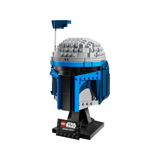
Members save More!
CAA Members receive additional savings on all items when shopping online and at CAA Stores.
Plus Members also receive an extra 5% off the Member pricing and Premier Members receive an extra 10% off the Member pricing.
Learn More

Members save More!
CAA Members receive additional savings on all items when shopping online and at CAA Stores.
Plus Members also receive an extra 5% off the Member pricing and Premier Members receive an extra 10% off the Member pricing.
Learn More

Members save More!
CAA Members receive additional savings on all items when shopping online and at CAA Stores.
Plus Members also receive an extra 5% off the Member pricing and Premier Members receive an extra 10% off the Member pricing.
Learn More

Members save More!
CAA Members receive additional savings on all items when shopping online and at CAA Stores.
Plus Members also receive an extra 5% off the Member pricing and Premier Members receive an extra 10% off the Member pricing.
Learn More

Members save More!
CAA Members receive additional savings on all items when shopping online and at CAA Stores.
Plus Members also receive an extra 5% off the Member pricing and Premier Members receive an extra 10% off the Member pricing.
Learn More


